


Enhancing Sentinel-2 Images for Accurate Identification of Rapeseed Crops in Mountainous Southwest China
-
摘要:
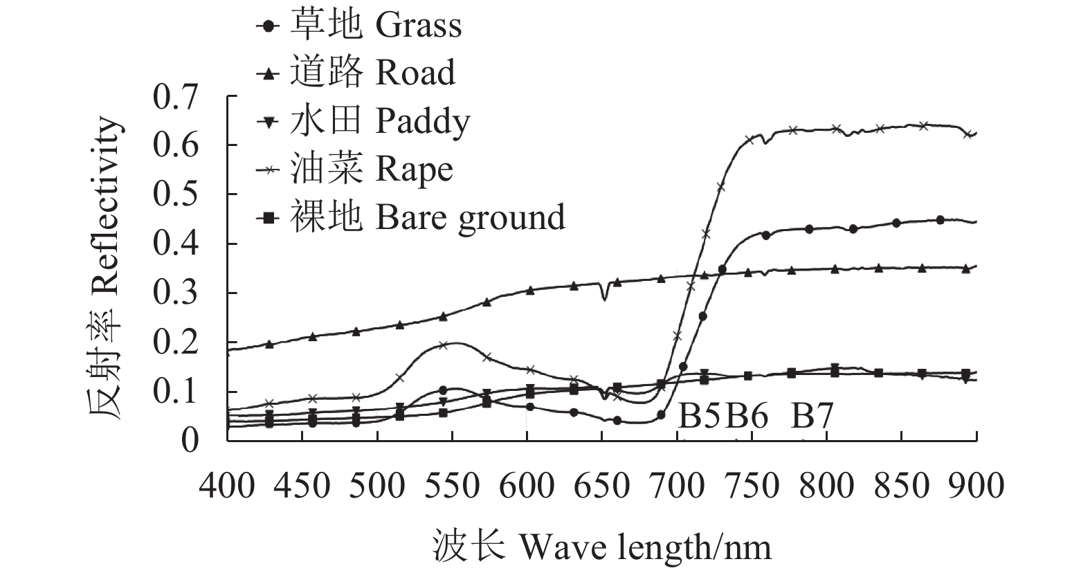
目的 由于Sentinel-2影像空间分辨率不足,目前难以在我国丘陵山区等复杂地区开展广泛应用。为进一步拓展其应用深度,本研究通过提高Sentinel-2数据空间分辨率,探索不同空间分辨率与光谱分辨率条件下低山丘陵地区作物遥感识别能力,为我国西南低山丘陵复杂地区农作物遥感识别研究提供参考。 方法 利用多光谱影像重建与融合技术,获取了Sentinel-2影像不同空间分辨率与光谱波段的多光谱影像,通过融合图像质量评价,特征波段光谱趋势分析及随机森林模型下不同空间分辨率与波段组合下油菜遥感识别精度对比及特征波段重要性度量,分析不同空间分辨率与光谱波段条件下地形复杂地区的油菜遥感识别能力。 结果 ①影像融合后图像亮度均有所增加,微小细节反差和纹理变化的表达能力明显增强,图像的清晰度有较大提高,主要地物融合前后灰度曲线变化趋势基本一致。②数据空间分辨率提高能够有效提高油菜作物分类精度,总体精度由72.29%提高到79.52%,Kappa系数从0.66上升到0.75;在同等分辨率条件下,红边波段有助于提高油菜作物的制图精度,从91.30%提高到95.65%。③不同红边波段对提高作物的识别精度效果存在差异,C2(可见光B2、B3、B4-红边B5-近红外B8)组合与C1(可见光B2、B3、B4-近红外B8)组合总体精度提高4.75%,C3(可见光B2、B3、B4-红边B5、B6-近红外B8)组合与C2组合总体精度提高1.21%,红边B5波段与红边B6波段有助于提高总体精度,且B5波段比B6波段更有效;C4(可见光B2、B3、B4-红边B5、B6、B7-近红外波段B8)与C3组合制图精度提高4.35%,用户精度提高0.57%,B7波段对于油菜作物制图精度提升效果较为明显;基于随机森林模型的特征波段归一化重要性度量值表明在较高分辨率条件下,可见光蓝色波段B2与绿色波段B3的重要性度量值分别为0.94和0.82,红边波段B7和红边波段B5度量值分别为0.89和0.75,与波段组合比较中红边B7与红边B5波段更有助于提升油菜制图精度与总体精度的结果较为一致。 结论 本研究通过多光谱影像重建与融合技术实现了Sentinel-2影像空间分辨率的大幅度提升,同时基于随机森林分类完成不同红边波段组合下的油菜提取结果的精度对比和特征波段重要性量化度量,首次较为全面地探索了Sentinel-2影像高分辨率条件下不同红边波段下油菜作物遥感识别能力,可为Sentinel-2影像分辨率提升研究及探索其更广泛的应用领域提供借鉴。 Abstract:Objective Means to upgrade the resolution of the images obtained by the currently available Slentinel-2 optical imagery technology were explored for better identification of rapeseed crops in mountainous southwest China. Method Sentinel-2 images of rapeseed crops acquired from the satellite in space were modified using image reconstruction and fusion technology to increase the spatial resolution by varying the spectral bands. Image quality as to how accurate it could recognize rapeseed crops was evaluated based on a random forest, complex terrain model. Result ① The fusion treatment significantly enhanced the contrast on minute details and texture changes, greatly improved the sharpness, and increased the brightness of the images. Meanwhile, the gray curves of the main features remained basically unchanged before and after the treatment. ② The enhanced spatial resolution effectively facilitated vegetation classification. The overall accuracy and Kappa coefficient differed slightly at the resolution of 2m. However, the crop mapping accuracy was significantly improved from 91.30% to 95.65% by the red edge bands applied. ③ Different red edge bands exhibited varying effects on the recognition accuracy. The combination of C2 (visible light B2, B3, and B4-red edge B5-near infrared B8) and C1 (visible light B2, B3, and B4-near infrared B8) increased the accuracy by 4.75%. The combined C3 (visible light B2, B3, B4-red edge B5, and B6-near infrared B8) and C2 enhanced the accuracy by 1.21%. Although both red edge B5 and B6 bands could improve the overall accuracy, B5 was more effective than B6. The combination of C4 (visible light B2, B3, B4-red edge B5, B6, 7-near infrared B8) and C3 resulted in an increase on the mapping accuracy by 4.35% as well as a user accuracy by 0.57%. The red edge B7 was most effective of all. The random forest model showed, under the improved conditions, the normalized importance metrics of characteristic band for the blue band B2 to be 0.94; for the green band B3, 0.82; for the red band B7, 0.89; and, for the red edge B5, 0.75. The results, consistent with those obtained under the band combinations, indicated that B7 and B5 bands contributed more significantly to the accuracy improvement. Conclusion The spatial resolution of Sentinel-2 images could be significantly enhanced through image reconstruction and fusion. The accuracy of rapeseed crop identification by various band combinations was analyzed by the quantitative measurements of the importance of characteristic bands under the random forest classification model to arrive at the conclusion. As the first comprehensive study of its kind, the information obtained would be of value for further applications of the Sentinel-2 imaging system. -
Key words:
- spatial resolution /
- red edge bands /
- Sentinel-2 /
- random forest /
- RS /
- hilly area
-

图 3 不同分辨率下融合图像比较
注:图像RGB组合为分别为B5、B6、B7波段
Figure 3. Fusion images of different resolutions
Note: RGB of image are B5, B6, and B7, respectively.

图 4 不同分辨率影像地物类型灰度曲线
Figure 4. Gray curves of land cover images of different resolutions

图 6 不同分辨率影像分类提取效果
Figure 6. Crop classification as affected by images of different resolutions

图 7 基于随机森林的归一化特征波段重要性度量
Figure 7. Importance measurement of normalized characteristic bands based on random forest model
表 1 Sentinel-2影像多光谱波段信息
Table 1. Multispectral band information on Sentinel-2
波段号
Band number波段
Band中心波长/nm
Center wave length/nm空间分辨率/m
Spatial resolution/mB2 蓝 Blue 490 10 B3 绿 Green 560 10 B4 红 Red 665 10 B5 红边 Red Edge 705 20 B6 红边 Red Edge 740 20 B7 红边 Red Edge 783 20 B8 近红外 NIR 842 10 B8A 红边 Red Edge 865 20  下载: 导出CSV
表 2 不同波段下原始图像与融合图像的指标比较
Table 2. Evaluation of fusion image index
波段号
Band number图像
Image亮度 Brightness 空间细节 Spatial details 光谱 Spectrum 均值
Mean标准差
Standard deviation平均梯度
Average gradient信息熵
Information entropy相关系数
Correlation coefficientB2 原始图像
Original image61.51 43.11 3.69 4.91 0.75 融合图像
Fusion image64.70 36.65 7.43 4.89 B3 原始图像
Original image81.39 56.52 4.08 5.20 0.78 融合图像
Fusion image86.18 49.13 10.29 5.17 B4 原始图像
Original image65.38 58.90 3.99 5.06 0.79 融合图像
Fusion image70.61 49.84 9.94 5.04 B5 原始图像
Original image119.13 71.09 3.32 5.14 0.85 融合图像
Fusion image124.96 62.99 12.30 5.24 B6 原始图像
Original image133.95 74.34 3.49 5.14 0.87 融合图像
Fusion image139.12 67.98 11.48 5.18 B7 原始图像
Original image133.67 74.08 3.47 5.12 0.87 融合图像
Fusion image138.73 67.98 11.24 5.18 B8 原始图像
Original image130.26 74.27 4.00 5.04 0.86 融合图像
Fusion image135.43 68.01 11.36 5.16 B8A 原始图像
Original image133.94 74.21 3.40 5.09 0.87 融合图像
Fusion image139.05 68.18 11.24 5.16
下载: 导出CSV
表 3 不同分辨率下分类精度比较
Table 3. Classification accuracy with images of different resolutions
数据
Data地类
Category制图精度
Producer’s accuracy/%用户精度
User’s accuracy/%总体精度
Overall accuracy/%Kappa系数
Kappa coefficientSentinel-2(10 m) 油菜/Rape 86.96 95.24 72.29 0.659 其他/Others - - Sentinel-2(2 m) 油菜/Rape 95.65 84.62 79.52 0.747 其他/Others - - GF-1(2 m) 油菜/Rape 91.30 91.30 81.93 0.775 其他/Others - -
下载: 导出CSV
表 4 不同波段组合下分类精度比较
Table 4. Classification accuracy under different band combinations
波段组合Band combination 地类Category 制图精度Producer’s accuracy/% 用户精度User’s accuracy/% 总体精度Overall accuracy/% Kappa系数Kappa coefficient C1(B2-B3-B4-B8) 油菜/Rape 95.65 78.57 73.56 0.676 其他/Others - - C2(B2-B3-B4-B5-B8) 油菜/Rape 95.65 81.48 78.31 0.731 其他/Others - - C3(B2-B3-B4-B5-B6-B8) 油菜/Rape 95.65 84.62 79.52 0.747 其他/Others - - C4(B2-B3-B4-B5-B6-B7-B8) 油菜/Rape 100 85.19 79.52 0.748 其他/Others - - C5(B2-B3-B4-B5-B6-B7-B8-B8A) 油菜/Rape 100 85.19 81.93 0.776 其他/Others - -
下载: 导出CSV
-
[1] 李宗南, 王昕, 蒋怡, 等. 基于RapidEye影像的石漠化区休耕地块监测 [J]. 中国农业资源与区划, 2019, 40(8):89−94.LI Z N, WANG X, JIANG Y, et al. Monitoring fallow farmland in rock desertification region by using rapideye image [J]. Chinese Journal of Agricultural Resources and Regional Planning, 2019, 40(8): 89−94.(in Chinese) [2] 乌云德吉, 于利峰, 包珺玮, 等. RapidEye卫星红边波段对主要农作物识别能力的影响研究 [J]. 北方农业学报, 2017, 45(6):118−123. doi: 10.3969/j.issn.2096-1197.2017.06.22WUYUNDEJI, YU L F, BAO J W, et al. Impact of red-edge wave band of RapidEye satellite on recognition ability of main crop [J]. Journal of Northern Agriculture, 2017, 45(6): 118−123.(in Chinese) doi: 10.3969/j.issn.2096-1197.2017.06.22 [3] 张卫春, 刘洪斌, 武伟. 基于随机森林和Sentinel-2影像数据的低山丘陵区土地利用分类——以重庆市江津区李市镇为例 [J]. 长江流域资源与环境, 2019, 28(6):1334−1343.ZHANG W C, LIU H B, WU W. Classification of land use in low mountain and hilly area based on random forest and Sentinel-2 satellite data: a case study of Li shi Town, Jiang jin, Chongqing [J]. Resources and Environment in the Yangtze Basin, 2019, 28(6): 1334−1343.(in Chinese) [4] 李龙伟, 李楠, 陆灯盛. 多时相Sentinel-2影像在浙西北茶园信息提取中的应用 [J]. 浙江农林大学学报, 2019, 36(5):841−848.LI L W, LI N, LU D S. Mapping tea gardens spatial distribution in northwestern Zhejiang Province using multi-temporal Sentinel-2 imagery [J]. Journal of Zhejiang A & F University, 2019, 36(5): 841−848.(in Chinese) [5] 郭文婷, 张晓丽. 基于Sentinel-2时序多特征的植被分类 [J]. 浙江农林大学学报, 2019, 36(5):849−856.GUO W T, ZHANG X L. Vegetation classification based on a multi-feature Sentinel-2 time series [J]. Journal of Zhejiang A & F University, 2019, 36(5): 849−856.(in Chinese) [6] SELVA M, AIAZZI B, BUTERA F, et al. Hyper-sharpening: a first approach on SIM-GA data [J]. IEEE Journal of Selected Topics in Applied Earth Observations and Remote Sensing, 2015, 8(6): 3008−3024. doi: 10.1109/JSTARS.2015.2440092 [7] WANG Q M, SHI W Z, LI Z B, et al. Fusion of Sentinel-2 images [J]. Remote Sensing of Environment, 2016, 187: 241−252. doi: 10.1016/j.rse.2016.10.030 [8] 梁丽娟, 黄万里, 张容焱, 等. Sentinel-2卫星影像融合方法与质量评价分析 [J]. 遥感技术与应用, 2019, 34(3):612−621.LIANG L J, HUANG W L, ZHANG R Y, et al. Sentinel-2 satellite image fusion method and quality evaluation analysis [J]. Remote Sensing Technology and Application, 2019, 34(3): 612−621.(in Chinese) [9] BRODU N. Super-resolving multiresolution images with band-independent geometry of multispectral pixels [J]. IEEE Transactions on Geoscience and Remote Sensing, 2017, 55(8): 4610−4617. doi: 10.1109/TGRS.2017.2694881 [10] 张焕雪, 李强子. 空间分辨率对作物识别及种植面积估算的影响研究 [J]. 遥感信息, 2014, 29(2):36−40.ZHANG H X, LI Q Z. Effects of spatial resolution on crop identification and acreage estimation [J]. Remote Sensing Information, 2014, 29(2): 36−40.(in Chinese) [11] 孔令婷, 杨英宝, 章勇. 基于不同分辨率遥感影像的分类方法对比研究 [J]. 测绘与空间地理信息, 2015, 38(3):40−43. doi: 10.3969/j.issn.1672-5867.2015.03.014KONG L T, YANG Y B, ZHANG Y. Study on classification methods based on different resolution remote sensing imga E [J]. Geomatics & Spatial Information Technology, 2015, 38(3): 40−43.(in Chinese) doi: 10.3969/j.issn.1672-5867.2015.03.014 [12] 王利民, 刘佳, 高建孟, 等. 冬小麦面积遥感识别精度与空间分辨率的关系 [J]. 农业工程学报, 2016, 32(23):152−160. doi: 10.11975/j.issn.1002-6819.2016.23.021WANG L M, LIU J, GAO J M, et al. Relationship between accuracy of winter wheat area remote sensing identification and spatial resolution [J]. Transactions of the Chinese Society of Agricultural Engineering, 2016, 32(23): 152−160.(in Chinese) doi: 10.11975/j.issn.1002-6819.2016.23.021 [13] 朝鲁门, 宁小莉, 包玉海, 等. 基于GF-2的沙地区域影像融合方法与评价: 以内蒙古自治区正蓝旗北部典型沙地为例 [J]. 水土保持通报, 2019, 39(4):138−143.CHAO L M, NING X L, BAO Y H, et al. Image fusion methods and evaluation in sandy area based on GF-2 Satellite data: a case study in north Zheng lan Banner of inner mongolia autonomous region [J]. Bulletin of Soil and Water Conservation, 2019, 39(4): 138−143.(in Chinese) [14] LI X J, CHEN G, LIU J Y, et al. Effects of RapidEye imagery's red-edge band and vegetation indices on land cover classification in an arid region [J]. Chinese Geographical Science, 2017, 27(5): 827−835. doi: 10.1007/s11769-017-0894-6 [15] WASKE B, VAN DER LINDEN S, OLDENBURG C, et al. imageRF – A user-oriented implementation for remote sensing image analysis with Random Forests [J]. Environmental Modelling & Software, 2012, 35: 192−193. [16] 杨珺雯, 张锦水, 朱秀芳, 等. 随机森林在高光谱遥感数据中降维与分类的应用 [J]. 北京师范大学学报(自然科学版), 2015, 51(S1):82−88.YANG J W, ZHANG J S, ZHU X F, et al. Random forest applied for dimension reduction and classification in hyperspectral data [J]. Journal of Beijing Normal University(Natural Science), 2015, 51(S1): 82−88.(in Chinese) [17] 刘会芬, 杨英宝, 于双, 等. 遥感图像不同融合方法的适应性评价: 以ZY-3和Landsat8图像为例 [J]. 国土资源遥感, 2014, 26(4):63−70. doi: 10.6046/gtzyyg.2014.04.11LIU H F, YANG Y B, YU S, et al. Adaptability evaluation of different fusion methods on ZY-3 and Landsat8 images [J]. Remote Sensing for Land & Resources, 2014, 26(4): 63−70.(in Chinese) doi: 10.6046/gtzyyg.2014.04.11 [18] 胥兵, 方臣. ZY-102 C星图像与ETM+图像融合方法及效果评价 [J]. 国土资源遥感, 2014, 26(3):80−85. doi: 10.6046/gtzyyg.2014.03.13XU B, FANG C. Data fusion methods of ZY-102 C and ETM+ images and effect evaluation [J]. Remote Sensing for Land & Resources, 2014, 26(3): 80−85.(in Chinese) doi: 10.6046/gtzyyg.2014.03.13 [19] 张小利, 李雄飞, 李军. 融合图像质量评价指标的相关性分析及性能评估 [J]. 自动化学报, 2014, 40(2):306−315.ZHANG X L, LI X F, LI J. Validation and correlation analysis of metrics for evaluating performance of image fusion [J]. Acta Automatica Sinica, 2014, 40(2): 306−315.(in Chinese) [20] 张焕雪, 李强子, 文宁, 等. 农作物种植面积遥感估算的影响因素研究 [J]. 国土资源遥感, 2015, 27(4):54−61. doi: 10.6046/gtzyyg.2015.04.09ZHANG H X, LI Q Z, WEN N, et al. Important factors affecting crop acreage estimation based on remote sensing image classification technique [J]. Remote Sensing for Land & Resources, 2015, 27(4): 54−61.(in Chinese) doi: 10.6046/gtzyyg.2015.04.09 [21] 刘佳, 王利民, 滕飞, 等. RapidEye卫星红边波段对农作物面积提取精度的影响 [J]. 农业工程学报, 2016, 32(13):140−148. doi: 10.11975/j.issn.1002-6819.2016.13.020LIU J, WANG L M, TENG F, et al. Impact of red-edge waveband of RapidEye satellite on estimation accuracy of crop planting area [J]. Transactions of the Chinese Society of Agricultural Engineering, 2016, 32(13): 140−148.(in Chinese) doi: 10.11975/j.issn.1002-6819.2016.13.020 -


 点击查看大图
计量
- 文章访问数: 965
- HTML全文浏览量: 328
- PDF下载量: 46
- 被引次数: 0
